


Beschreibung von Map Area Measure Pro
Measure area on the map.
How to use
https://yosapa.com/doc/area_meas_e.pdf
Function.
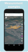
1. Measure the land area.
2. Measure the distance.
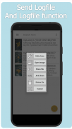
3. Share information through the app.
4. Save image data.
5. Save measurement data. Can be retrieved later.
6. Get the address automatically.
How to use.
1. Select the map as desired.
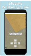
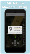
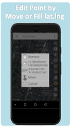
2. Press and hold on the map at the point you want.
3. Press the finger icon to remove it.
4. Press the Finger icon directly to move the point.
5. Press the button> Send photos to line or Facebook.
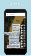
- New function Add point by walk.
- New edit point
- Save polygon logfile and send to other person.
- Open logfile and edit logfile.
- Add Change Map Type
- Normal Map
- Satellite Map (Recommend use)
- Satellite Map With Label
- Terrain Map
- New Completed Draw Polygon design
- add function add point
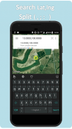
- add search bar can search by word or latitude,longitude (separate lat,lng by , ; : or space).
- add search bar can search log in local phones.
- add myLocation Icon with GPS accuracy (+- m).
- add function draw polygon area by GPS with myLocation with GPS accuracy (+- m). This function can use by click myLocation with GPS accuracy to place point in map. (this function need to walk around land area)
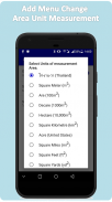
Add Units of measurement Area.
1. ไร่-งาน-วา (Thailand)
2. Square Meter (m2)
3. Are (100m2)
4. Decare (1000m2)
5. Hectare (10,000m2)
6. Square Kilometre (km2)
7. Acre (United States)
8. Square Miles (mi2)
9. Square Feet (ft2)
10. Square Yards (yd2)
For more information Or report a crash at
bunjong.yosapa@gmail.com
https://yosapa.com
https://www.facebook.com/bysty/
Messen Sie Bereich auf der Karte.
Wie benutzt man
https://yosapa.com/doc/area_meas_e.pdf
Funktion.
1. Messen Sie die Landfläche.
2. Messen Sie den Abstand.
3. Geben Sie Informationen über die App.
4. Speichern von Bilddaten.
5. Speichern von Messdaten. Kann später abgerufen werden.
6. Holen Sie die Adresse automatisch.
Wie benutzt man.
1. die Karte auswählen, wie gewünscht.
2. Drücken und halten Sie auf der Karte an der Stelle, die Sie wollen.
3. Drücken Sie die Finger Symbol, um es zu entfernen.
4. Drücken Sie den Finger Symbol direkt auf den Punkt zu bewegen.
5. Drücken Sie die Taste> Senden Fotos Linie oder Facebook.
- Neue Funktion Punkt zu Fuß hinzufügen.
- Neuer Bearbeitungspunkt
- Polygon Logfile speichern und an andere Personen senden.
- Öffnen Sie Logfile und bearbeiten Logfile.
Hinzufügen Typ Change Map -
- Normal-Map
- Satellitenbildkarte (empfohlene Nutzung)
- Satelliten-Karte mit Etikett
- Geländekarte
- Neu abgeschlossene Draw Polygon-Design
- Funktion add Punkt hinzufügen
- Suchleiste hinzufügen, indem Wort oder Breite, Länge (getrennter lat, lng durch,;: oder Leerzeichen) suchen kann.
- Suchleiste hinzufügen können in lokalen Telefonen suchen einloggen.
- (- m +) MyLocation Icon mit GPS-Genauigkeit hinzuzufügen.
- (- m +) Funktion draw Polygonfläche von GPS mit MyLocation mit GPS-Genauigkeit hinzuzufügen. Diese Funktion kann durch Klick MyLocation mit GPS-Genauigkeit verwendet Punkt in der Karte zu platzieren. (Diese Funktion benötigt um Landfläche zu Fuß)
In Maßeinheiten Bereich.
1. ไร่ - งาน - วา (Thailand)
2. Quadratmeter (m2)
3. Ist (100m2)
4. DeCare (1000m2)
5. Hektar (10.000m2)
6. Quadratkilometer (km2)
7. Acre (USA)
8. Quadratmeilen (mi2)
9. Square Feet (ft 2)
10. Platz Yards (yd 2)
Für weitere Informationen oder einen Absturz melden bei
bunjong.yosapa@gmail.com
https://yosapa.com
https://www.facebook.com/bysty/
Map Area Measure Pro – Version 2.2.14.92
(20-02-2024)
Map Area Measure Pro – APK Informationen
APK Version: 2.2.14.92Paket: com.bunjongy.landareameasure_proApps in derselben Kategorie
Das könnte dir auch gefallen...


